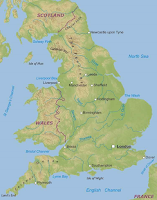
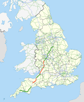
After collecting my primary research on cartography I realised that although it provides a large variety of cartography my research lacked in explaining the modern purposes of different types of maps therefore I decided to collect some secondary research. I used websites and blogs to collect images and information on the purposes. The six most common uses of cartography are Climate maps, Economic/resource maps, political maps, road maps and topographic maps.
"Climate maps give information about the climate and precipitation (rain and snow) of a region. Cartographers use colours to show different climate or precipitation zones." - FactMonster
If I were to use this style of map as inspiration I would be able to explore the use of colour which I feel could be really intriguing within the design process.
Economic/Resource Maps
"Economic or resource maps feature the type of natural resources or economic activity that dominates and area. Cartographers use symbols to show the locations of natural resources or economic activities. For example, oranges on a map in Florida tell you that oranges are grown there." - FactMonster
If I were to explore illustration this could be a really interesting form of inspiration however I am exploring more of a 3D pathway and I can't really think of a creative way in which to combine this style of map with 3D.
 Physical Maps
"Physical maps illustrate the psychical feature of an area, such as the mountains, rivers and lakes. The water is usually blue. Colours are used to show relief differences in land elevations. Green is typically used for lower elevations, and oranges or brown indicates higher elevations." - FactMonster
Due to the representation of elevations of the land I could very easily combine this style of map with 3D however I want to include portraiture; I suppose I could create sculpture where the face is representative of mountains and incorporate the use of colour like on the map.
"Political maps do not show physical features instead, they indicate state and national boundaries and capital and major cities. A capital city is usually marked wit a star or circle." - FactMonster
Although I have explored simplifying by looking at the works of Jazzberry Blue and researching street maps however that would require having something more complex to simplify in the first place; this style of map is too simple to thoroughly develop further.
 Road Maps
"Road maps show major - some minor high ways - and roads, airports, railroad tracks, cities and other points of interest in an area. People use road maps to plan trips and for driving directions." - FactMonster
Road maps can be extremely intricate and can produce interesting patterns as seen from Ed Fairburns illustration work. Off the top of my head I can think of various techniques or materials that I could use
with this style of map therefore I will continue to explore using this style of map within my work
"Topographic maps include contour lines to show the shape and elevation of an area. Lines that are close together indicate steep terrain, and lines that are far apart indicate flat terrain." - FactMonster
Similar to a physical map I could explore the use of colour and land elevation within 3D when being inspired by this style of map. Although a physical map shows the land elevation its focal point is the physical features such as lakes and rivers however a topographic map focuses solely on the height of the land. I could focus on the elevations across the surface of the face perhaps creating a sculpture combing 3D, cartography and portraiture successfully.
Similar to a physical map I could explore the use of colour and land elevation within 3D when being inspired by this style of map. Although a physical map shows the land elevation its focal point is the physical features such as lakes and rivers however a topographic map focuses solely on the height of the land. I could focus on the elevations across the surface of the face perhaps creating a sculpture combing 3D, cartography and portraiture successfully.
With this secondary research being the last of my research into cartography I now have a wide range of maps: from the roman era to last weeks climate map, each with different purposes, various scales, uses of shape and colour. By having such a wide range of research I can make a well informed decision as to what map will influence me the most during the design processes of my project. I will explore the use of road maps and topographic maps further before I decide which of the maps I will use to influence me.


No comments:
Post a Comment